A boundary line is a dividing line that delineates the geographical boundaries of two countries.
Our country, India, has a 15,200 km long land border with seven other countries:
- Afghanistan (North West) – 80 km,
- Bhutan (North) – 587 km,
- Bangladesh (East) – 4,096 km,
- China (North) – 3,917 km,
- Myanmar (East) – 1,458 km,
- Nepal (North) – 1,752 km, and
- Pakistan (West and North West) – 3,310 km
as well as marine borders with Sri Lanka, Maldives, and Indonesia.
Did you know what all the national and international borders were called? If not, let's keep learning.
Boundary Lines: India
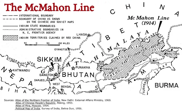
McMahon Line
- Between China & India.
- Length – 890 km.
- Demarcated by & named after – Sir Henry McMahon (foreign secretary of British India and the chief British negotiator).
- After the Simla Convention of July 3, 1914, a bilateral agreement for clear demarcation was reached between Sir Henry McMahon of Britain & Lonchen Shatra of Tibet.
- Came into effect – March 24-25, 1914.
- It runs from Bhutan's eastern border along the Himalayan crest until it reaches the great bend in the Brahmaputra River when it exits from its Tibetan path into the Assam Valley.
- India recognizes the McMahon Line and considers it to be the 'Actual Line of Control (LAC)'
- China disputes the legal status of this line after its occupation of Tibet in 1950.
- After 1950, Tibet lost its independent status, and India took over the Tawang region of Arunachal Pradesh.
- China claims Tibet always was its own territory, and therefore the Shimla Pact was not acceptable as they were a non-party.
Radcliffe Line
- Between India & Pakistan.
- Length – 3,323 km.
- Demarcated by – Sir Cyril Radcliffe (Chairman of the Border Commission).
- Bengal Boundary Commission & Punjab Boundary Commission.
- Came into effect – 17 August 1947.
- A crude border was already built by Lord Wavell, the Viceroy of India along before the existence of Radcliffe Line.
- It extends from the Rann of Kutch in Gujarat to the international border in Jammu in Jammu & Kashmir, separating India and Pakistan.
- It includes present-day India, Bangladesh and Pakistan.
- The western side of the line is known as the Indo-Pakistani border and its eastern side is the Indo-Bangladesh border.
- Indo-Pakistani border (2,900 km)
- 5 crossing points –
- Attari, Ganda Singh Wala, Hussainiwala, Munnabao & Wagah.
- States /UTs located –
- Punjab (547 km) – the smallest state in the region on the Radcliffe Line.
- Rajasthan (1070 km) – State with the maximum extent with Redcliffe Line.
- Gujarat (512 km) – State with the lowest range with Redcliffe Line.
- Jammu & Kashmir (1216 km) – share the longest border with Pakistan.
- The newly drawn boundaries caused one of the largest human migrations in modern history, displacing around 14 million people and killing over one million.
- Disputed areas – Chittagong Hill Tracts, the Gurdaspur district, districts of Malda, Khulna, and Murshidabad (Bengal) and the sub-division of Karimganj (Assam).
- Indo-Pak wars over border conflicts – 1947, 1965, 1971 & the Kargil conflict of 1999.
Line of Actual Control (LAC)
- Military boundary line between China & India.
- In 1962, China attacked India and captured the 'Aksai Chin' territory; in 1963, China established a truce but refused to leave the Aksai Chin area. It is now known as the Line of Actual Control, or LAC.
- The length varies; the Chinese government believes the LAC to be roughly 2,000 kilometres long, whereas India considers the LAC to be 3,488 kilometres long.
- LAC is divided into three regions:
- Western sector in Ladakh,
- Middle sector in Uttarakhand & Himachal Pradesh, and
- Eastern sector in Arunachal Pradesh & Sikkim.
Line of Control ( LOC)
- Military boundary line between India & Pakistan.
- Location – Jammu & Kashmir.
- Length – 776 Km.
24th Parallel
- Between India & Pakistan.
- It is located in the Sir Creek region in the great Rann of Kutch (Gujarat).
- Pakistan claims that it is the boundary between India and Pakistan. However, it is not recognized by India.
Palk Strait
- Between Tamil Nadu (India) & Mannar district of Sri Lanka.
- Named after – Robert Palk, a British governor of Madras Presidency (1755–1763).
- It connects the Bay of Bengal in the northeast with the Palk Bay and with the Gulf of Mannar in the southwest.
Apart from the above mentioned major boundary lines which separate the Indian Subcontinent from the other countries, there is the Indo-Nepal border in Uttrakhand, UP and Bihar, the Indo-Bhutan border in Sikkim, Assam and Arunachal, Indo-Myanmar border in Arunachal Pradesh, Nagaland, Manipur and Mizoram.
Boundary Lines: International
Durand Line
- Between Pakistan & Afghanistan.
- Length – 2,430 Km.
- Delimited by – Sir Mortimer Durand.
- signed an agreement between Sir Mortimer Durand and Abdur Rahman Khan, erstwhile Amir of Afghanistan.
- Signed on – November 12, 1893 (Kabul, Afghanistan).
- It cuts through the Pashtun tribal areas and further south through the Balochistan region.
- Present-day Afghanistan does not recognize the Durand line.
Hindenburg Line
- Between Poland & Germany.
- Built in – 1916-1917.
- It was a German Defensive line in French territory during World War I.
- It was rendered irrelevant by the treaty of Versailles in 1919.
Maginot Line
- Between Germany & France.
- Built in – 1930s.
- Named after French Minister of War of 1930, André Maginot.
- Before World War II, it was a defence line along the French border with Germany.
- After Germany's successful invasion of France following the onset of World War II, the Maginot line was declared obsolete.
Mannerheim Line
- Between Russia & Finland.
- During World War II, Finland created this as a defence line against the Soviet Union during the Winter War.
Medicine Line / 49th Parallel
- Between USA & Canada.
- It is located 49 degrees north of the equator.
- The 49th parallel is known as the "Medicine Line" due to its allegedly supernatural power to keep US soldiers from crossing it during expeditions in the 1800s.
- It marks the international border between the northern United States (except Alaska) and Canada and was established following the Anglo-American Convention of 1818 and the Oregon Treaty of 1846.
Oder-Neisse Line
- Between Poland & Germany.
- Built on Karelian Isthmus.
- It runs along the rivers Oder and Lusatian Neisse rivers.
- The line was constructed in two phases: 1920-1924 & 1932-1939.
- It demarcates the Polish-German border according to the Potsdam Conference. It was recognized by a unified Germany in 1990.
Siegfried Line
- Between France & Germany.
- Siegfried means Westwall in German.
- It was created by the Weimar Republic (the German government from 1919 to 1933) and later the Third Reich of Germany in the 1930s as an expansion of the Hindenburg defensive line on the western front of World War I.
Blue Line
- Between Lebanon & Israel.
- The United Nations issued a boundary delineation between Lebanon and Israel on June 7, 2000, in order to determine if Israel had fully withdrawn from Lebanon.
Green Line / Attila Line / UN Buffer Zone
- Between The Republic of Cyprus & Turkish Cyprus.
- Built in – 1964 (extended in 1974).
- after the ceasefire of 16 August 1974.
- A demilitarized zone monitored by the United Nations Peacekeeping Force in Cyprus (UNFICYP).
17th Parallel
- Between South Vietnam & North Vietnam.
- The 17th latitude from the equator divided erstwhile North and South Vietnam.
- It was demarcated based on the 1954 Geneva Accords.
- After the unification of Vietnam in 1976, it became obsolete.
20th Parallel
- Between Libya & Sudan.
- It is located at the 20th northern latitude which is used as the border between Sudan and Libya.
22nd Parallel
- Between Egypt & Sudan.
- The Sudan-Egypt border is marked by the 22nd latitude north of the equator.
25th Parallel
- Between Mauritania & Mali.
- This line marks the northernmost portion of the Mali-Mauritania boundary.
31st Parallel
- Between Iran & Iraq.
- It also serves as a dividing line between the US states of Louisiana and Mississippi.
38th Parallel
- Between South Korea & North Korea.
- The 38th parallel divides the significant centre of the Demilitarized Zone between North and South Korea.
- It was designated as an army border by US military strategists at the Potsdam Conference (July 1945) near the conclusion of World War II.
You will note that one or two questions will always come from this topic, especially if you are preparing for public exams such as Kerala PSC 10th level, plus two-level, and degree level prelims or even main exams.
And the names of these international boundary lines are simple to remember.
Thanks for reading!!!


Post a Comment
Post a Comment